Still on a wave of euphoria from the salar experience I head south for the lagunas the following morning. I ride with a German friend of mine who is on a well set up airhead GS. He has no interest in riding the more remote route through the south so we will part ways in San Cristobal where he will head for the Ollague border crossing. The skies are blue but weeks of steady rain leaves the jeep routes enveloped in a froth of chocolaty mud and water. After a half hour of riding we look like the kid who took a dip in Willy Wonka’s chocolate river. We cover the 60 miles to San Cristobal efficiently and Paul and I say our goodbyes after topping off. I will run in to him again in San Pedro de Atacama.
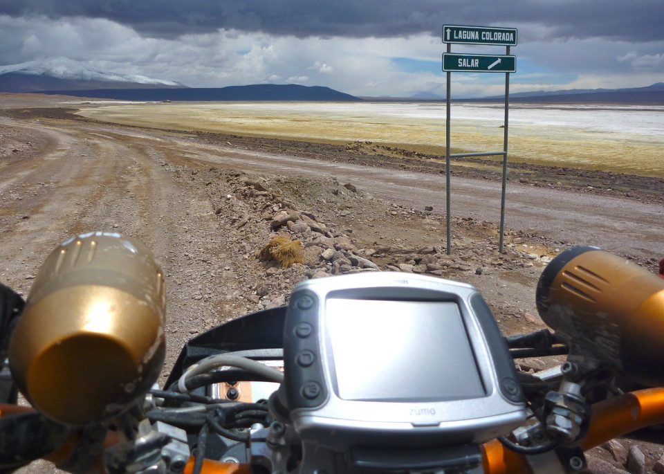
I head south from Villa Alota on one of the smaller jeep routes. There are a number of jeep tours running south to Laguna Colorado but they’re staying on the main road and taking the western route south. I wind through the Valle de Roca until I find myself facing a nasty stretch of flooded road. I see a construction crew attempting to construct a make shift overpass through the lake that has taken over the road. It seems odd to run into people this far out but I’m happy to see them. Unfortunately they haven’t been here long so I’ll be taking the lake route. The workers turn when they hear me approaching and watch intently as if they’re waiting for the carnage. The bike sinks into the wet sand as I ride out each of the flanks looking for a more accommodating place to cross. The water depth and ground saturation seems to worsen the farther I get from the road. I return to the road and dismount to get a better look on foot. One of the workers directs me to where they are building up the road. They have about 10 feet of runway that drops off into a wet abyss that stretches for another 20 yards or so before reaching the other side of the road. The water is dark green and dotted with mossy vegetation that I find odd in a high plain desert. I decide to give it a go, I’ve crossed worse and at least there are people here so I won’t be stranded if I go down. I roll the bike off the edge of the “ramp” and the front wheel is immediately submerged and the steep decline catches me off guard. The rear of the bike with all the luggage is damn near straight up and feels like it’s coming over on top of me. I immediately throw my weight back, pushing the luggage back with my ass, and crack the throttle. The front pops up and the rear crashes down into the water with a big splash. I stay on the throttle as the bike oscillates from side to side and the knobbies churn the water with green algae and mud. I reach the other side and turn back to the workers who are now drenched from my splash but jumping up and down cheering. They do love the drama in Latin America.
A friend in Uyuni tells me about some lake houses in Villa Mar so I plan to stop there for the night. I figure camping on a lake would be nice and I can get some grub there. I pick up a series of small tracks that appear to route me into Rio Mallcu just north of Villa Mar. The small tracks are actually in better shape than the main routes and very scenic. I enjoy this part of the day and don’t stop much as the route is just sublime and it’s nice not needing to negotiate a vat of mud or a river crossing. I arrive at a check point on the edge of Villa Mar where the guard indicates the river has flooded the road and directs me to a desvio where I can cross the river. I ride along the river on the opposite bank of the pueblo and don’t see any sign that other vehicles have been this way. As I ride back toward the checkpoint a resident motions me toward his position to cross. There are no tracks and the water is very dark with loads of algae. Again, I throw caution to the wind only this time I float the front wheel over the edge and cross with no commotion. This is where I notice it. There’s no lake here. I look at the GPS and it’s indicating I have another 20 miles to reach Villa Mar and that my current location is Mallku Villa Mar. Weird. I hadn’t noticed there were “two” Villa Mars previously.
The sun is in its afternoon descent but I figure I have plenty of time to cover the remaining distance and set up camp in daylight. As I near the location I think is Villa Mar I don’t see anything resembling a town, in fact my location is quite remote with no sign of life. When I refer to the GPS route the destination labeled “Villa Mar” is no longer visible and has disappeared. I recount the details of the conversation I had with my friend in Uyuni and recall the events at Mallku Villa Mar and I have no explanation as to how I ended up where I am. The sun is going down, there are dark clouds looming, and it’s been spitting rain on me for an hour now. I’m less than 20 miles north of Culpina and decide to press on as I’m not keen on back tracking. I figure there should be infrastructure there for the mining operation and I should be able to find some food and a place to throw down my tent. Culpina has a decent size salar and like Uyuni it’s flooded and spilling onto the road. I end up riding the edge of the salar as it’s in better shape than the road. I reach the pueblo and speak with one of the mine operators to learn there is no place to get food in town in spite of my map indicating there is. That basically means they have food and won’t be sharing any with me. I press on. When I get to the park entrance the ranger explains where I can find a hostal though I don’t fully comprehend his directions. The rain is holding steady at a light drizzle and the sky appears darker than it is due to the storm clouds. I see no sign of life on the eastern side of the laguna so I get off the trail and circumnavigate the lake from the south.
I spot a mirador with a few parked jeeps and some backpackers milling about taking in the scenery. As I’m ripping through the rock bed toward the mirador a number of the backpackers start waving me down. They sure seem excited, I think to myself. It turns out they’re some Swiss friends of mine I met in Uyuni. They saw me in Villa Alota and apparently one of the other jeep drivers told them I would never make it through the route I turned on to. Their excitement fills me with a sense of accomplishment and they give me directions to the hostal where they’re staying. The folks running Hostal Marcello are very accommodating, they give me a private room and even cook for me even though I have no reservation and supplies are limited. I have a couple cocktails with friends and go to sleep in a warm bed with a full stomach. It was a good day on the altiplano.
I sleep like a rock and the sun is high by the time I awake. All the jeep tours except one have left. I walk outside and pause to take in the beauty that was concealed by the previous day’s clouds and darkness. The sky is bright and covered in white fluffy clouds. I struggle to see the snow capped peak in front of me but the clouds are relentless. After a quick breakfast and parting conversation with friends I get on a track and meander south toward the geisers. I bought gas from a jeep driver last night so I have a full tank and full stomach, a great start to the day. I explore the tracks around what I believe to be Cerro Pabellon and I’m awestruck by the land I’m riding in. It’s like another planet. A red-centric colorful high desert plain possessing only a smattering of organic life, punctuated with dozens of perfect snow capped peaks towering well over 5000 meters, wind swept rock formations, salars, hot springs, geysers, and pink flamingoes. Can Mars sustain pink flamingoes? I get back on the main road and see the sign for the Aduana yet no station is in sight, more on that later. I hit the geisers and make my way south to the park station. The snow capped peaks lining the road to the station look like something out of a painting. The hot springs at Salar de Chalviri are tempting but not enough to compel me to endure the effort of getting out of my gear, a seemingly simple activity that takes on a new meaning at 15K ft.
It’s now that I have to own up to my lack of planning. I’ve packed no food and not certain I can find any out here. I didn’t have the wherewithal to ask the folks at Hostal Marcello if they could spare some additional food. They were already very generous to feed me two meals. My fork seals are completely blown now, the brake pads are saturated in oil and not doing a good job of stopping the bike, and the bike is frequently bottoming out. I’m not optimistic I can find a dry place to set up camp, the only dry places appear to be in the open desert where the winds are quite strong, and I’m not keen on camping in the mud. Given this set of circumstances I decide to head for the Chilean border. This acknowledgment leaves me a bit melancholy but it is what is and I motor south to Laguna Verde. Again, Laguna Verde looks like something out of surrealism painting, it’s no wonder Dali was inspired by this place. I ride around the area looking for tracks I can explore in an effort to gain another vantage point for what is the finale of the Bolivian segment of my trip. After some procrastination I arrive at the Bolivian immigracion to learn I missed the aduana station. Apparently that sign I passed, and took a picture of, was telling me to go to Apacheta, wherever that is. This little oversight costs me $20US but it beats riding back 40km to the station. It’s been a while since a border gave me grief, I must be getting better at this.
(not actual route but close, Bing maps not cooperative)


VIDEO
Tags: ADV, Adventure Travel, Altiplano, Bolivia, KTM 950, Laguna Colorado, Laguna Verde, Parque Avaroa, Salar de Uyuni, SE, Super Enduro, Superenduro, Valle de Dali, Villa Alota